Aerial Drone Photography – California Memorial Day Motorcycle Run 2014
by biker1
Aerial Drone Photography
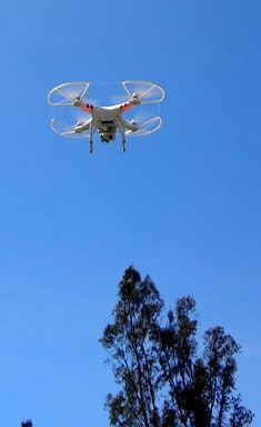
This is video 2 of 2 on the West Coast Thunder motorcycle run Memorial Day 2014. To view the first video, Click Here. Here, I’m using a DJI Phantom 2 Vision Plus aerial drone to get the HD video of the run.
This is the largest motorcycle run west of the Mississippi!
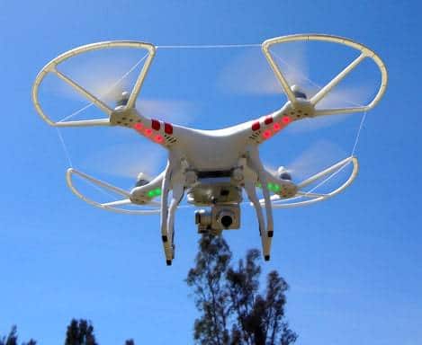
The Phantom 2 Vision+ is very EZ to operate because it uses GPS to hold it’s location and auto return to takeoff & land itself if it loses the control signal. This quadcopter comes with an integrated 14-megapixel/1080p camera and tilt-axis gimbal which provide super smoothy video footage.
Real time Stabilization, Great aearial imagery to the next l(stadium, football, sports, motocross, skiing, live concerts) – video always looks very smooth.
The Phantom 2 Vision+ has an extremely high quality camera and comes with a 4GB micro SD card. It shoots full HD video at 1080p 30, 720p 60 for clean slow motion and takes 14 megapixel stills from the air! Plus, you can tilt the camera as you fly, so you can create the graceful moving shot you see in your mind.
You can send photos and videos from the Vision+ straight to your phone using Wi-Fi. No computer required. Also, the Wi-Fi range is over 2,200 feet! If you need more distance, there are already 3rd. party upgrades available.
Exceeding the control range of the remote control will trigger ‘Return-to-Home’. The Phantom 2 Vision+ will automatically fly back to its takeoff point and land safely without any pilot input!
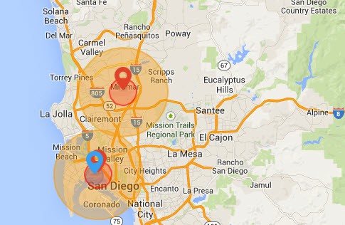
In order to increase flight safety and prevent accidental flights in restricted areas, the new firmware for the Phantom 2 series includes a No Fly Zones feature to help users use this product safely and legally.These zones include airports worldwide and have been divided into two types, A and B. The photo below is what the DJI No-Fly zones are for San Diego, California:
In the A (darker color) zone you cannot takeoff and in the B zone (lighter color) the flying height is restricted on a sliding scale from 35 feet to 400 feet.


Great use of the drone for the motorcycle run!